
價格:免費
更新日期:2018-09-19
檔案大小:59.2 MB
目前版本:81.0.0
版本需求:需要 iOS 8.0 或以上版本。與 iPhone、iPad 及 iPod touch 相容。
支援語言:俄文, 巴克摩文挪威文, 德語, 法文, 瑞典文, 芬蘭文, 英語, 荷蘭文
This App offers access to marine vector covering UK/Ireland waters (derived from UKHO data). First marine GPS app to have route assistance with Voice Prompts for marine navigation. You can create new boating routes or import existing GPX/KML routes. It supports Nautical Charts course up orientation. Includes Tide & Currents prediction.
►FEATURES
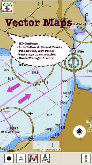
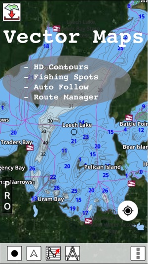
√ Beautiful and detailed Hardware/GPU accelerated vector charts (text stays upright on rotation)
√ Long press to query the details of Marine object (Buoy, Lights, Obstruction etc).
√ Customizable depth(Ft/Fathom/Meter) and distance units (km/mi/NM)
√ Customizable Shallow Depth.
√ Record tracks, Autofollow with real-time track overlay & predicted path vector.
√ Voice Prompts for marine navigation (requires GPS )

√ 1ft / 3ft depth contour maps for anglers for selected lake maps.
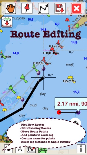
√ Supports GPX/KML for boating route editing/import.
√ Tide & Currents prediction.
√ Seamless chart quilting of marine charts
√ Enter or import Waypoints.
► MAPS
The maps include coverage of coast of UK & Ireland (derived from UKHO data).
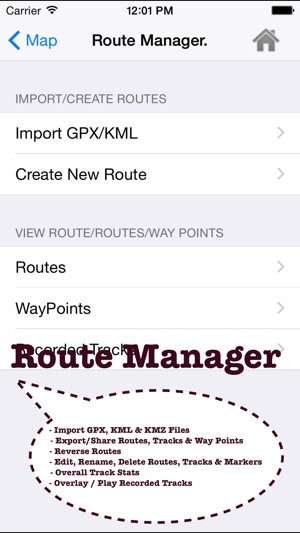
►ROUTE MANAGEMENT / TRIP PLANNING

√ Create New Route/Edit Existing Routes
√ Move Points
√ Add points to an existing route leg
√ Delete / Rename points
√ Import GPX, KML & KMZ files
√ Plot/Edit Routes
√ Enter Waypoints
√ Share/Export Routes, Tracks & Markers

√ Reverse Routes
►GPS FEATURES
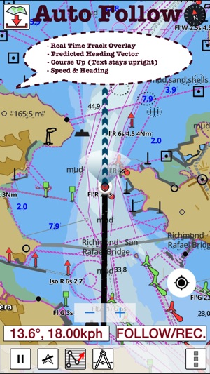
√ Auto Follow
* Real Time Track Overlay
* Predicted Path Vector
* Course Up (Text stays upright)
* Speed & Heading
√ Route Assistance With Voice Prompts
* Prompts when approaching a boating route marker
* Continous distance and ETA updates
* Alerts when sailing/boating off route
* Alerts when boating in wrong direction
√ Record Tracks
►TIDE & CURRENTS
* For US, Canada, UK, Germany & New Zealand
* High/Low Tides
* Tidal Current Prediction
* Active Current Stations
► SHARING
* Share tracks/routes/markers on Facebook & Twitter
* Export tracks/routes/markers as compressed GPX files.
Sample Nautical Charts (please visit http://gpsnauticalcharts.com/main/nautical-charts-united-kingdom)
►BRISTOL CHANNEL & SOUTH IRELAND
►ENGLAND S COAST & SCILLIES
►IRELAND W C-KENMARE R-FORELAND
►IRISH SEA
►N&E SCOTLAND-LEWIS-FORTH-N ISLES
►NORTH SEA-FORTH-THAMES ENTRANCE
►SCOTLAND KINTYRE-LOCH BROOM
►THAMES-MEDWAY & APPROACHES
支援平台:iPhone, iPad